
Map #11 Daughter Colonies
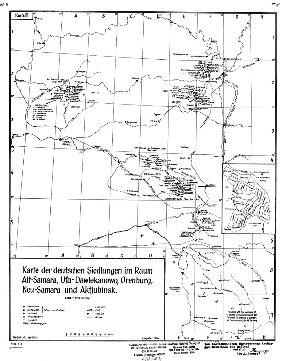
Map Of German Daughter Colonies
(Karte der deutschen Siedlungen im Raum Alt-Samara, Ufa-Dawlekanowo, Orenburg, Neu-Samara und Aktjubinsk)
Cartographer: Karl Stumpp
Size: 22 x 17 inches
Map description: Map of Daughter Colonies founded between 1859 and 1913 between Longitudes 49o and 57o and between Latitudes 49o and 56o. All of these Daughter Colonies were founded by Black Sea Germans except 4 which were founded by Volga Germans.
Northeast of the major original Volga colonies and includes the Russian cities of Samara (now Kuibyshev), Ufa, and Orenburg (known as Chkalov 1938-1957).
AHSGR Map # 11 Translation
Map Title: Karte der deutschen Siedlungen im Raum Alt-Samara, Ufa-Dawlekanowo, Orenburg, Neu-Samara und Aktjubinsk: Map of the German Settlements in the region of Old Samara, Ufa-Dawlekanowo, Orenburg, New Samara and Aktjubinsk
Bearb. v. (Bearbeitet von) Dr. K. Stumpp: wrought by Dr. K. Stumpp
Schwarzmeerdeutsche: Black Sea Germans
Mennoniten: Mennonite
evangelisch: Protestant
katolisch: Catholic
Wolgadeutsche: Volga Germans
erloschen: extinct
(1890) Gründungsjahr: foundation (year of founding)
Eisenbahn: railroad
Fluß: river
russ. Ort: Russian place
Grenze: border
Nachdruck verboten: reproduction prohibited
Ausgabe 1964: 1964 edition
Dem Amerikanischen Historischen Archiv der Deutschen aus Rußland: The American Historical Archive of the Germans from Russia
verehrt: venerated
Miscellaneous:
Karte III: Map 3 (upper left)
alt: old
Kolonien: colonies
Abkürzungen: abbreviations
Wald: forest
od. (oder): or
Dörfer: villages
Gegr. (gegründet) 1890: founded in 1890
viele deutsche Gutshöfe: many German estates
Landplan: map
$13Members save $5.00!
Become a member